Nashville residents stunned to find out they’re now living in flood plains
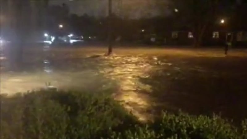
NASHVILLE, Tenn. (WSMV) - When March’s flood in Crieve Hall surged into Ashley Nussmeyer’s crawlspace, it caused a pricy mess.
“We have to get all new duct work, $4,000 to $5,000 worth of duct work,” Nussmeyer said.
None of the costs were covered because she doesn’t have flood insurance.
She didn’t need it, as her home of nine years wasn’t in a flood plain.
Which is why she reacted with surprise when News4 Investigates told her, according to pending flood maps in Davidson County, she is now in a flood plain.
“Oh wow. That’s news to me. I did not know that,” Nussmeyer said.
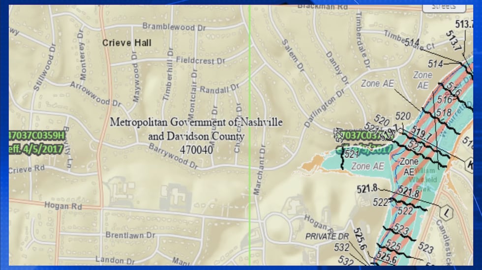
When you look at the current FEMA flood map for her neighborhood, completed in 2017, you can see where her home stands on Arrowwood Drive is several streets away from the closest flood plain.
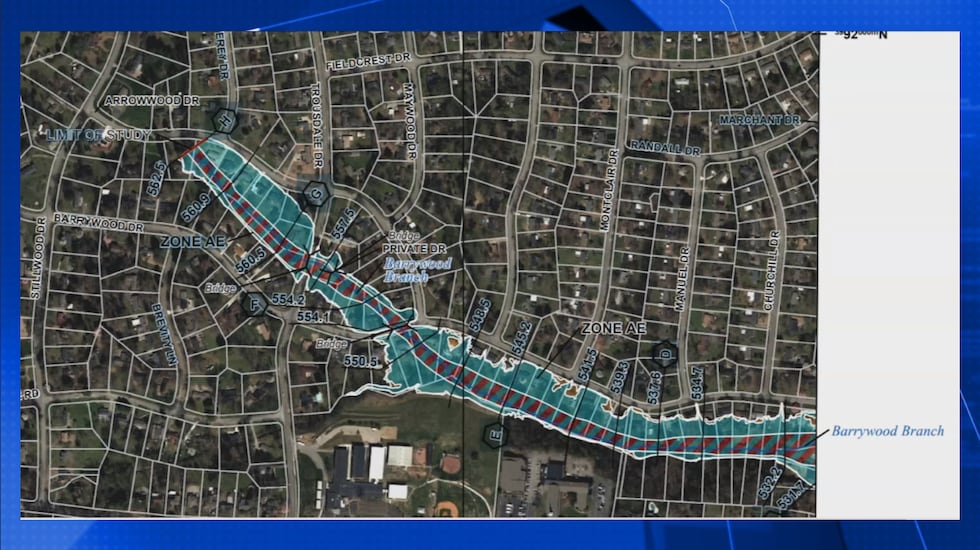
But new flood maps, conducted by the Army Corps of Engineers and confirmed through FEMA, show her home and others on one section of Arrowwood are now squarely in a flood plain.
“Completely unexpected when there hasn’t been any flooding other than that one flood,” Nussmeyer said.
Nussmeyer added that last year’s flooding at her house originated from ditches across the street that weren’t dug correctly and that the creek behind her house did rise beyond its bank but did not reach her house.
News4 Investigates found not only was Nussmeyer’s section of the street now in a flood plain, but that all the houses on the adjoining Barrywood Drive are also in a flood plain.
“I’m shocked. It doesn’t make any sense. This isn’t an area that floods often,” Nussmeyer said.
The new maps, 11 of which were approved last year with 72 scheduled to be approved in February, mark areas that have never been studied before.
Mary Viera, a senior engineer with FEMA, said new technology allows the agency to better analyze areas for potential flooding.
“Have these people always been in flood plains and never knew it?” News4 Investigates asked.
“Correct. Just because they’ve lived there and it’s never flooded doesn’t mean it has a chance of flooding,” Viera said.
William Terry, chief of the water resources for the U.S. Army Corps of Engineers, said the new maps concentrate on areas with creeks and streams that haven’t been analyzed before.
The maps show which areas are in a 100-year flood plain (a 1% chance of flooding each year) and a 500-year flood plain.
News4 Investigates reviewed the maps and found a concentration of new flood maps around Seven Mile Creek and streams on the fringes of the county.
Terry confirmed that if people live in houses with federally-backed mortgages that are now deemed to be in a flood plain, they will most likely have to buy flood insurance.
“We’ve simply identified risks for people, and now those people have an opportunity to mitigate that risk,” Terry said.
Once all 81 maps are approved, homeowners will get letters from the city officially alerting them to the change.
If you want to see if your home is now in a flood plain, click here.
Here are the next steps:
- In the search engine bar on the left side of the screen, enter your full address.
- Once your street is pulled up, you will see to the very right of your screen what looks like three diamond shapes stacked on top of each other.
- You will see a layer list with five options to choose from.
- To see if your hose is in the latest flood map, approved in 2017, check the “effective FIRM panel.” If your home is not shaded in blue or brown, and no change occurs to the map (except that a long number that pops up and the effective date of 4/5/2017) then your home was not in a flood plain at that date. If it is blue or brown, you are an existing floodplain as of 2017.
- To see if your house is now deemed to be in the flood maps that are pending or have just been approved as of 2021, the select “Preliminary national flood hazard layer.” If your property is in blue or brown, you are now in a flood plain.
Copyright 2022 WSMV. All rights reserved.


