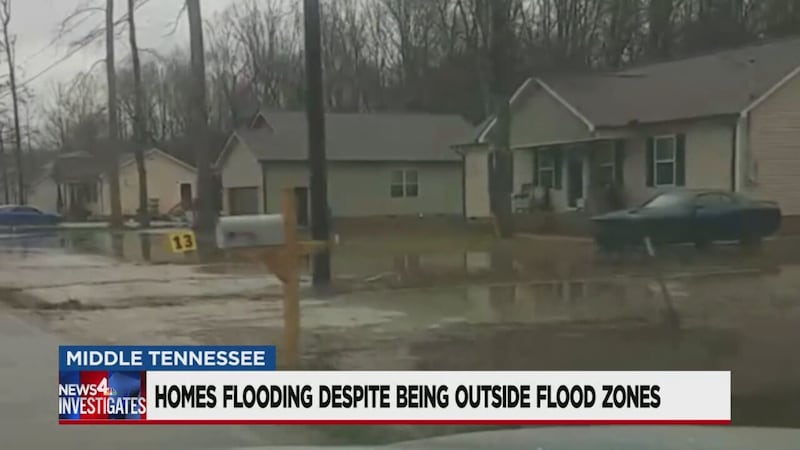
Neighbors blame city, federal government for basing flood zones on outdated maps


NASHVILLE, Tenn. (WSMV) - Melissa Phothirath thought she was buying a brand new house, not an island.
“It looks like we’re in the middle of a flowing river in front and back,” Phothirath said.
Her next-door neighbors say they too did not buy a house on Forrestwood Drive in Manchester for a water view.
“Literally the front of the house, the sides of the house, the back of the house are always underwater,” said homeowner Britney Hamilton.
Both Phothirath and Hamilton bought brand new homes along the edge of a flood zone and were told by developers not to worry.

“They did say several times that it’s not in a flood plain. It’s not in the flood plain,” Phothirath said.
But they both have documented the substantial flooding they get after a heavy rain, in which water surrounds the front, back, and sides of their house, even seeping underneath.
News4 Investigates found the flood map from FEMA that determines their flood zone is twelve years old.
“Knowing that map is so old, what do you think?” asked News4 Investigates.
“That’s extremely frustrating that they would even go by that map,” Phothirath said.
And News4 Investigates found other neighborhoods built on the edges of flood zones that area also flooding.
Gwen Frazier’s brand new home was built half on a flood plain and half, not in flood plain and said the floods they see after heavy rain was strong enough to tear down their neighbor’s fence.
The FEMA flood zone map for the area outside of Frazier’s house is 13 years old.

All of the homeowners News4 Investigates interviewed said they were not required to buy flood insurance because they are not in a flood zone.
“It’s a major problem. I feel like we’ve been misled,” Frazier said.
Mark Vieira, a senior engineer with FEMA, agreed to an interview with News4 Investigates about the maps the neighbors believe are outdated.
“Because these maps are so old, does that indicate that these neighborhoods shouldn’t have been built there in the first place?” asked News4 Investigates.
“That’s a good question,” Vieira said.
Vieria pointed out that FEMA is not in charge of approving where houses can and cannot be built.
“Some of these maps are 12 years old. Is that acceptable?” asked News4 Investigates.
“If you look at the criteria, there’s a possibility that it’s OK,” Vieira said.
Vieria said while the maps may be old, they are assessed every five years, and a local flood plain administrator, usually in a city codes department, can ask that a specific area be studied by FEMA at any time.
Vieria said in neither the new builds in the neighborhoods in Manchester or La Vergne was FEMA asked, by codes departments, to determine if certain flood zones had expanded.
“It is their job to see is this development is going to be reasonably safe from flooding,” Vieria said.
Our repeated requests for interviews from Lavergne and Manchester’s codes department were denied.
Jamie Sain, Manchester’s flood plain administrator, did send emails, writing, “The City is attempting to resolve the drainage issues in this area. At this point, we do not think an interview with the media would help those efforts….The city followed its floodplain ordinance that meets all of the minimum standards of the National Flood Insurance Program. It is not the city’s responsibility to ask FEMA to update their maps on a regular basis.”
Sain went on to email to say the developer of the new building did his own survey and found that the flood plain ended at the end of the properties.
“At the end of the day, they just pass the buck,” Phothirath said.
Phothirath said with no one taking responsibility, she’d had to make the toughest choice possible: move out of her brand new home.
“I crawled under my house six weeks ago. There was standing water on the tarp,” she said. “(There was) mold all on the crossbeams. We’ve been sick for months.”
If you’d like to see how close you live to a flood plain and how old the FEMA map is beside your property, type in your address by clicking here.
Copyright 2020 WSMV. All rights reserved.