First Alert Forecast: Very hot, humid end to the weekend
Showers, storms will become more widespread by mid to late week.
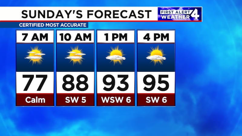
THE NEXT 24 HOURS
Sunday will turn very hot and humid like the 4th of July and Saturday. After a warm and muggy early morning, only isolated thundershowers are possible. Rain chance, 20%. High, 95.

For life-saving weather alerts, customized messages on conditions and forecasts, and videos detailing upcoming weather events, download the WSMV 4 First Alert Weather app for iPhone or Android. Have weather pictures or videos? Share them here.
SUNDAY’S FORECAST
Morning: Mostly sunny, very warm, and humid. Low, 74.
Afternoon: Turning very hot and staying muggy. High, 95. Rain chance, 20%.
Evening: A dissipating shower or storm possible. Temperatures in the 80s.
MONDAY’S FORECAST
Morning: Partly cloudy, very warm, and humid. Low, 74.
Afternoon: Spotty showers and thunderstorms. Turning very hot and staying humid. High, 94. Feeling like the upper 90s. Rain chance, 30%.
Evening: A few showers and storms with temperatures in the 80s.
TUESDAY & BEYOND
Tuesday will bring a higher chance for showers and storms -- 40%.
Count on a 50% chance on Wednesday and Thursday as humidity remains high, but heat backs off slightly.
The pop-up storm chance will decrease to 30% on Friday and Saturday.


