Click on the orange button at the bottom of this page to sign up for RSS feeds

Project Background:
This study seeks to better understand the vulnerability of people and communities in the USDA Forest Service Pacific Southwest region (Region 5) to climate-related changes to National Forests and provide information to managers in support of forest planning activities. Forest ecosystems are susceptible to a changing climate through multiple pathways, both directly and indirectly through changes in vegetation. The alteration of ecosystem function then impacts the quantity and quality of goods and services provided by forests. In addition, climate-related changes may also affect disturbance regions, such as wildfire, that can directly affect the well-being of people and communities.
This research will contribute to an existing research program developed for other geographic regions within the US Forest Service on the economic relationships between ecosystem services and the people and communities who may be affected by ecosystem changes. The primary contribution of this post-doctoral position is to conduct an assessment of the socio-economic impacts of climate-related changes to National Forest lands in the Pacific Southwest (primarily California).
Job Description:
 Ever-wet tropical forests, which have high annual rainfall and are aseasonal, harbor exceptional species diversity. These ever-wet zones currently cover 30% of the tropical forest biome, half of which remains as intact forest, but with only 6% protected.
Research by Emma Underwood, Allan Hollander, and Jim Quinn at the Information Center for the Environment together with colleague David Olson at Conservation Earth, used downscaled climate data projections for 2050 to estimate that these ever-wet zones are likely to decrease by at least 20% under future climates. The research also indicated that this would result in a loss of one-fifth of extant intact ever-wet tropical forest and one-quarter of the protected ever-wet tropical forests by 2050. The researchers found that a shift towards increasing variability in rainfall, rather than decreases in areas that receive high amounts of annual precipitation, was the main driver of this change.
The tropical forests which are currently ever-wet and will remain ever-wet in the future provide important refuges for biodiversity. Their protection, as part of a global conservation strategy, offers the best chance for thousands of wet-forest species to persist.
The full study, Ever-wet tropical forests as biodiversity refuges, appears in the September issue of Nature Climate Change.
Ever-wet tropical forests, which have high annual rainfall and are aseasonal, harbor exceptional species diversity. These ever-wet zones currently cover 30% of the tropical forest biome, half of which remains as intact forest, but with only 6% protected.
Research by Emma Underwood, Allan Hollander, and Jim Quinn at the Information Center for the Environment together with colleague David Olson at Conservation Earth, used downscaled climate data projections for 2050 to estimate that these ever-wet zones are likely to decrease by at least 20% under future climates. The research also indicated that this would result in a loss of one-fifth of extant intact ever-wet tropical forest and one-quarter of the protected ever-wet tropical forests by 2050. The researchers found that a shift towards increasing variability in rainfall, rather than decreases in areas that receive high amounts of annual precipitation, was the main driver of this change.
The tropical forests which are currently ever-wet and will remain ever-wet in the future provide important refuges for biodiversity. Their protection, as part of a global conservation strategy, offers the best chance for thousands of wet-forest species to persist.
The full study, Ever-wet tropical forests as biodiversity refuges, appears in the September issue of Nature Climate Change.
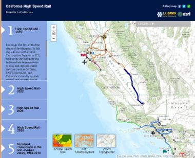 Over the past several months, employees at the Information Center for the Environment (ICE), in the Department of Environmental Science & Policy at UC Davis, in collaboration with the California Strategic Growth Council, and noted journalist for The Atlantic magazine, James Fallows have been working on a storymap to help better tell the story of the recently update buisness plan for the California High Speed Rail (HSR).
This storymap is a featured part of James Fallow's July 9th blog post for The Atlantic, 'The California High-Speed Rail Debate--Kicking Things off.'
This collaboration grew out of a conversation between ICE's retired co-founder (and now Executive Director of the California Strategic Growth Council) Mike McCoy and ESRI founder Jack Dangermond while Mr. Dangermond was visiting UC Davis. Over the past year, in fits and starts, ICE assisted Mike McCoy on a largely volunteer basis with assembling the data needed to paint a geographic picture of the HSR's recently updated buisness plan.
Through this process, it has become clear that the HSR is much more than just the construction of high speed rail. It is a major reinvestment in passenger rail that spans the state making substantial investments in many local and regional rail transit systems.
Over the past several months, employees at the Information Center for the Environment (ICE), in the Department of Environmental Science & Policy at UC Davis, in collaboration with the California Strategic Growth Council, and noted journalist for The Atlantic magazine, James Fallows have been working on a storymap to help better tell the story of the recently update buisness plan for the California High Speed Rail (HSR).
This storymap is a featured part of James Fallow's July 9th blog post for The Atlantic, 'The California High-Speed Rail Debate--Kicking Things off.'
This collaboration grew out of a conversation between ICE's retired co-founder (and now Executive Director of the California Strategic Growth Council) Mike McCoy and ESRI founder Jack Dangermond while Mr. Dangermond was visiting UC Davis. Over the past year, in fits and starts, ICE assisted Mike McCoy on a largely volunteer basis with assembling the data needed to paint a geographic picture of the HSR's recently updated buisness plan.
Through this process, it has become clear that the HSR is much more than just the construction of high speed rail. It is a major reinvestment in passenger rail that spans the state making substantial investments in many local and regional rail transit systems.

The most recent statewide surveys documented a rapid decline in the number of Tricolored Blackbirds, from about 400,000 in 2008 to about 250,000 3 years later. Annual monitoring and research into the relationship between reproductive success (RS) and insect abundance by ICE ecologist Bob Meese has shown a chronic low RS in dozens of colonies studied since 2007 and relatively high RS only in instances when colonies were surrounded by landscapes with unusually high insect abundance. Thus, the recent decline in the numbers of tricolors is believed to be due to chronic low RS (the number of birds recruiting into the population has been much smaller than the number dying) due to insufficient insect abundance. For the full story, please visit the Tricolored Blackbird Portal.
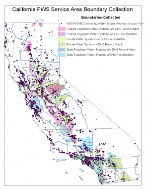
Some of the latest research conducted utilizing the boundaries collected through ICE and uploaded to the California Department of Public Health Environmental Health Tracking Program or CEHTP, the CDPH entity behind the creation of the online geographic tool.
The Information Center for the Environment (ICE) has enjoyed a long, lustrous relationship with the California Department of Public Health, (CDPH). One of our latest projects involves collecting drinking water service area boundaries for the state of California and creating a geospatial statewide dataset for CDPH use. Recently, the project has also caught the eye of CalWARN, a Wastewater Agency Response Network who is interested in the collection for emergency purposes. For example, in the event California experiences a Hurricane Katrina type catastrophe, this data will direct us to the most vulnerable water systems and cut off their distribution to prevent water supply contamination. However, California's drinking water systems come in a variety of categories.
At today’s staff meeting, Geography graduate student Prashant Hedao, presented his work on the rehabilitation of coastal communities impacted by the 2004 tsunami in southern India. Hedao joined forces with his wife Lata Iyer, Regional Planner, to research feasible long-term solutions for Tamil Nadu state government to implement in coastal areas targeted by tsunamis, other extreme weather events, and a rise in sea level. Due to the tragic 2004 Indian Ocean earthquake off the coast of Sumatra that resulted in a tsunami, impacting 14 countries, the Indian government lacked a holistic approach to tsunami planning and rehabilitation strategies.
Hedao and Iyer used applications from GIS, remote sensing, and ecological restoration of coastal ecosystem, while working with other experts at the Knowledge/Coordination Centre in Auroville, near Pondicherry. The Centre was a collaboration among government agencies and NGO’s working to prepare the coastal areas for disaster planning, and to mitigate impacts of the 2004 tsunami. Because the topography in coastal cities is very low lying and prone to sea level rise and coastal erosion, Hedao and Iyer sought more long-term solutions—such as promoting sand dunes as natural first lines of defense, and encouraging mangrove conservation. Read more about Hedao and Iyer’s work at the ESRI website (see below).
Laurel Torney and Kyle Shipley, both Junior Specialists at ICE, participated in a UC Davis Extension class; Studio 30: Studio Planning and Design seminar; last quarter and got a taste of current urban and landuse planning in the City of Davis. Torney adds, "The class has been very rewarding and it has been great doing some real-world work in the planning profession."
Here's a little more about Studio 30: The class is taught by Jeff Loux and Julia Johnston of the Land Use and Natural Resources divison of the UC Davis Extension. The class consists of both planning professionals as well as undergraduate and graduate students involved in planning-related studies. Fall and winter quarter was designed to aid the City of Davis' innovation park Task Force execute a feasibility study about building an innovation park in the City of Davis. In Spring 2012 and the continuing quarters, the class will work with AECOM in Sacramento for the City of Lodi's Climate Action Plan.
For more information about the class, being offered in Spring 2012, visit the website below.

The second annual International Seminar on Climate Change and Natural Resources Management took place from May 8_29, 2011 in Washington, D.C. and California. This was the second Seminar funded by the United States Forest Service International Programs (USFS IP) and involved 22 participants from 19 different countries as well as 8 leadership team members from USFS IP, the University of California, Davis (UCD), and the Training Resources Group (TRG).
Natural resources management under climate change requires complex cooperation between diverse regional governments, national parks, NGOs, and researchers. The diverse range of climate change’s impacts requires research, mitigation, and adaptation practices that interact with all aspects of community life. In response, the Seminar presentations ranged from researchers, to policymakers, to field-level resource managers and researchers, who provided a wide range of information and prompting spirited interdisciplinary discussions. The Seminar Leadership Team provided the context for each day’s presentations so that participants could relate the presentation topics to their countries and assess the strengths and weaknesses of different strategies.
There has been a decline in Lebanese forests by more than 35% over the last 50 years. Increasingly, there has been a serious need for more forested areas in the country. Aside from providing restoration to sites with important ecological, cultural and watershed values, the planting of Lebanese cedar and other native trees is aimed to alleviate poverty and promote unity and pride for the once-thriving Lebanese forests.
Through funding from the United States Forest Service and the United States Agency for International Development/Lebanon, we hosted 3 Lebanese geographers working on a Reforestation Initiative. The Initiative focuses on planting native trees on public lands in order to improve water quality and storage, aquifer recharge and a broader purpose in mitigating the effects of climate change. While visiting UC Davis, the group observed a number of restoration sites including:
ICUL, (pronounced i, cool) Wickson Hall people know how to get around. Through coordination and collaboration, Wickson Hall ICE and ULTRANS coworkers have seen 2 art exhibits and one stinky flower on campus this year.
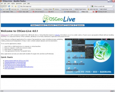
In collaboration with the Open Source Geospatial Foundation (OSGeo), ICE graduate student researcher Alex Mandel is proud to annouce the availability of OSGeo Live, version 4 "Barcelona". The new release includes many new applications, updated documentation, tutorials and a common dataset of the Barcelona area derived from free sources. Along with the latest release a 25 minute video presentation describing 42 of the geospatial applications available for use can be viewed online or downloaded.
OSGeo Live is a collection of Free and Open Source geospatial software configured to run from a DVD, USB or Virtual Machine with no installation. It's based on the Xubuntu Linux operating system, which is a community developed system in worldwide use and works great for laptops, desktops and servers. Over 42 Free and Open Source geospatial applications have been installed and pre-configured for use including sample data and basic instructions to get a new user started.
At the FOSS4G 2010 conference in Barcelona over 800+ copies were given to the attendees of the conference. Some possible uses for OSGeo Live include in the classroom, workshops, demonstrations, and testing of new software. Because the hardware requirements are few, it will run on most modern computers including netbooks.
For more information or to download a copy visit the project homepage at http://live.osgeo.org.
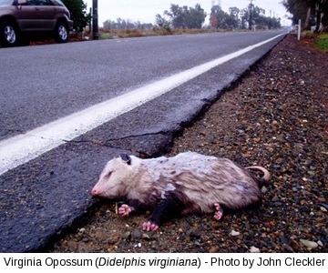
According to the Humane Society of the United States, over a million animals are killed every day on our roads and highways. The UC Davis Road Ecology Center and the Information Center for the Environment (ICE) are collaborating to reduce this number, and have setup the California Roadkill Observation System (CROS) where citizen-based observations of vehicle related animal deaths can be recorded and stored. By recording vehicle related deaths, "hot spots" will become more identifiable, and ways to mitigate the stretch of road can be addressed.
On September 13th, the CROS project was featured in a New York Times article (technology and science sections). During the day, the website saw a tremendous increase in traffic, which including many new registered users and email correspondence from people applauding our efforts. This national attention has draw a lot of interest from people, many who would like such a system in their home state. We are currently supporting sites in California and in Maine. The Maine Audubon Wildlife Road Watch was built in collaboration with Maine Audubon.
